Jim Cameron
"In a driving snow storm yesterday afternoon at 3 o'clock, the remains of Edward Ryan, who went to his death unsuspectingly, with a jest on his lips, were carried to the little grave yard on the east side of town and laid to rest. Rev. Ball officiated and only a few were present at the final ceremony." – Herald Newspaper, March 30, 1899.
So therefore:
1) the weather was not very nice on March 29, 1899;
2) Edward Ryan did not foresee his death — he was, in fact, Cranbrook's first murder victim, but that is a tale for another day, and;
3) he was buried in the little graveyard on the east side of town.
Now that last one raises a big question mark because the Cranbrook graveyards are situated on the west side of town and have been since the Old General Cemetery opened for business shortly after Mr. Ryan was laid to rest on the east side.
But where on the east side? There has been much speculation over the years as to exactly where Cranbrook's first cemetery was located. A common theory holds somewhere in Baker Park, near what was once the outdoor Gyro Swimming Pool and now the outdoor skating rink, but over the last century the exact location has been lost. Furthermore, it seems doubtful that the Baker family would have allowed a public cemetery on their immediate property and in such close proximity to their home.
Most references to the original east cemetery mention its size, or lack of it, so it is reasonable to assume that there weren't many pioneers buried there. As to how many, well, five might be a reasonable guess if one accepts the accuracy of the city's accounting of those who were removed from the East Cemetery and reinterred in the Old General Cemetery at some unspecified time, presumably not long after it opened in early 1900.
A present day cemetery city map indicates five plots marked "From Old Cemetery" but only one of them is given a name, that of Henry Seelye, the first customs agent of Joseph Prairie, whose combination office and residence was supposedly situated somewhere near the site of the east cemetery in which he was buried following his death in 1876.
Mr. Seelye, largely due to his efforts in helping British Columbia become a self-governed province of Canada, was considered important enough to keep track of when his remains were moved; the others, not so much.
Mrs. Anna Brown, age 35 — the first female fatality of the city — may be among the re-interred. Mention is made of her being laid to rest in the east cemetery and there are fleeting references to others but, as to the handful of those who died between 1898-99, there seems to be no proper record of the site of their burial, their removal or the re-interment, if that was the case.
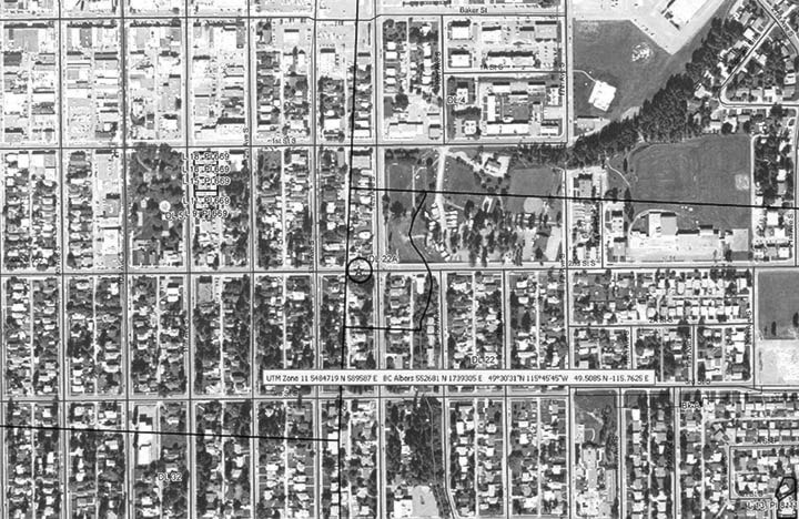
As to the location of the cemetery itself, there is little to go on. There is a map, or part of a map, actually a not very legible old photocopy of part of a map from 1877, herein referred to as the "Ralph" map, after William Ralph, the civil engineer who drew the original, which may still be out there somewhere (the remnant in question comes via David Humphrey and the Cranbrook Archives).
The original Ralph map gives a few block numbers, a few landmarks — Joseph’s Creek and the Walla Walla Trail and, most importantly in this case, a small area labeled “graveyard.” This was all that Resource Information Technician Wendy Walsh and Land Officer Nicole McKechnie of the Ministry of Forests, Lands & Natural Resources had to work with when they recently ascertained that the 1877 Ralph map appeared to accurately reflect present day outlines and thus, when the original map was carefully overlaid upon the present day city of Cranbrook, the location of the original cemetery was identified accordingly.
It is, of course, a calculation based on a very small amount of available information and dependant upon the assumption that the cemetery marked on the Ralph map is that of Cranbrook’s first burial ground. If so, it was situated somewhere very near the intersection of 14th Avenue and 2nd Street.
As far as cemeteries go, it would have been a nice spot in the days before the city began spreading beyond its boundaries, which happened rather quickly and might account for the necessity of removing both the cemetery and those laid within. It would also indicate that the original Custom’s House, the first real building in what became our city, would have been nearby and would further give a general location for the Walla Walla Trail, a much-travelled path for the miners of yore. The trail would have roughly paralleled the creek, running at an angle from the south of town, cutting through 13th and 14th Avenue, through Baker Park and onward to its eventual destination of Fisherville on the Wild Horse Creek. The precise location of the cemetery, the trail and the Custom’s House, would certainly be worthy of note and, although the Ralph map combined with modern technology points to one location, things are still open to speculation.
As to whether Cranbrook’s first graveyard was at this location, well, there’s no way to know for a fact at present. Perhaps further research will give up the answer. In the meantime, those living in the general area may not wish to dig too deep when planting their gardens, unless they’re keen on history, of course.