Trevor Crawley
Kimberley’s reservoir has hit historic lows and mandatory water restrictions were recently adopted by the municipal council.
So if there are concerns about water levels in Kimberley, what does that mean for Cranbrook?
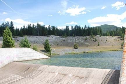
The city issued a press release at the beginning of the month noting that Phillips Reservior — Cranbrook’s primary source of potable water —is at capacity.
Despite the implementation of voluntary watering restrictions at the end of last week, the Phillips Reservoir is still currently at capacity, according to Joe McGowan, the Director of Public Works for the City of Cranbrook.
“At this date [the reservoir is full], however, that could change,” McGowan said. “And that’s the big thing, is to recognize that our reservoir is full at this moment and we are actually spilling water.
“However, the situation could change in very short order in a one- to two-week period. It could result in a significant change and we could very well be put in a position where we’d have to enforce significant water restrictions.”
Public Works is continually monitoring reservoir levels and water quality to ensure there is ample water supply for city residents.
The reservoir is served by inflow from Joseph Creek and Gold Creek, which is monitored and controlled at a diversion building.
McGowan says there are a few factors that could impact the water levels to drop.
“High temperature combined with low precipitation will result in less inflow to the Phillips Reservoir,” he said.
Should water levels drop below 75 per cent capacity, without the necessary inflow to increase the volume, there is a second phase of water management that the city will implement as part of the Outdoor Water Management policy.
The current voluntary restrictions means that the city will discontinue watering at a few selected greenspaces and parks. Further restrictions could include additional city properties and adjustments to flows for underground sprinklers by up to 30 per cent.
Across the province, low stream flows has forced the Ministry of Environment to adjust drought ratings.
The Kootenay region is classified at a Level 2 by the Ministry of Environment, meaning that the area is dry. The Okanagan is at Level 3, while the Lower Mainland and Vancouver Island is at Level 4.
The drought ratings have also forced angling closures in the most severely affected areas.