After a weekend of heavy smoke and ash falling in Kimberley, the fire situation surrounding Kimberley and throughout the Southeast Fire Centre remains busy.
Evacuation alerts were issued for both the Ta Ta Creek area (121 addresses) and the St. Mary Lake area (65 addresses).
Both those fires held at 1000 hectares and 165 hectares respectively.
The following is the latest update from the Regional District of East Kootenay on the situation throughout the fire centre:
There are currently 2 evacuation ORDERS in effect in the RDEK:
1. Cross River Fire / Nipika Mountain Resort for 9 properties 2. Leach Creek Fire – for 10 properties in the community of Corbin and Coal Mountain mine property. Please note: there are NO orders or alerts in place for the District of Sparwood.
There are also 3 evacuation ALERTS in effect:
1. In the Ta Ta Creek Area for the Lost Dog Complex Fires 2. One property near the Canada/US border southeast of Yahk for the Randal Creek Fire 3. Electoral Area E in the St. Mary Valley and St. Mary Lake area for the Meachen Creek Fire - Please note: there are NO ALERTS OR ORDERS for either Kimberley or Marysville at this time.
This is a long post - but here’s a bit of a round up of some of the fires in the region. Note, this is not an exhaustive list - as we’ve had a number of new fire starts in the past 24 hours. To see all the latest info and all the fires, visit www.bcwildfire.ca
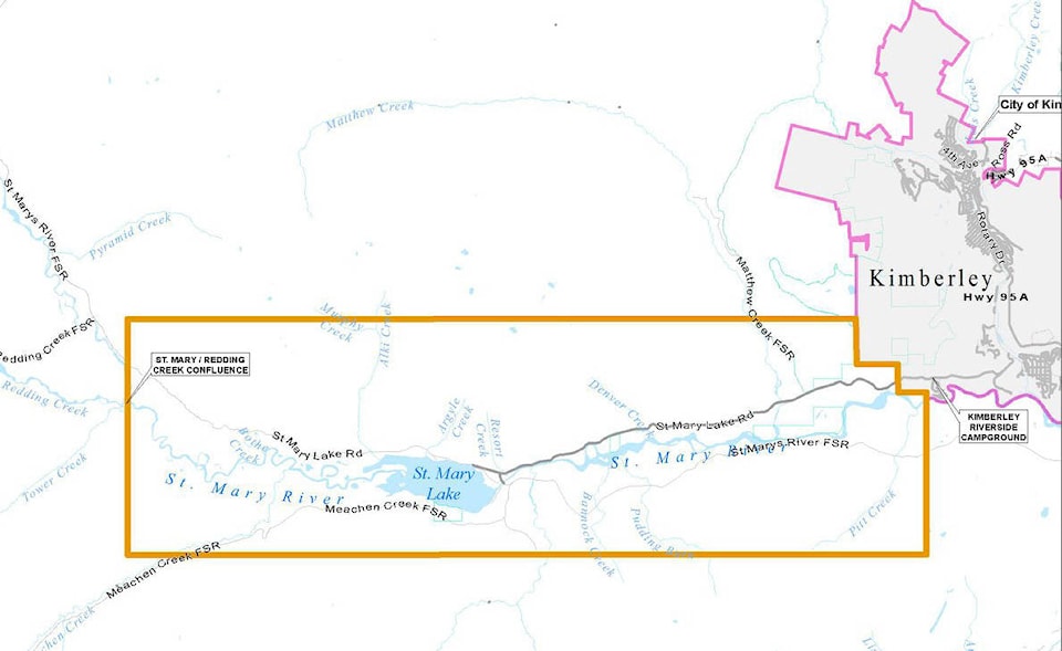
Meachen Creek - St. Mary Lake - (N11886)
The fire is burning at the north end of Kianuko Provincial Park approximately 25.5 km southwest of St. Mary Lake. The fire is estimated at 1000 hectares. This fire is producing heavy smoke and residents of Kimberley and surrounding communities have been experiencing ash fall. An evacuation ALERT for 65 addresses was issued Saturday evening and remains in place. The Meachen Creek Forest Service Road is now closed starting at the 16 kilometre mark at the junction of the Meachen Creek and White Boar forest service roads. Visit http://bcfireinfo.for.gov.bc.ca for more info on this fire and maps of the road restrictions. In addition, BC Parks has also issued a partial closure of Kianuko Provincial Park. Visit their website for additional information at: http://www.env.gov.bc.ca/bcparks/explore/parkpgs/kianuko/
Lost Dog Complex Fire (N12413)
Evacuation ALERT remains in place for 121 address points in the Ta Ta Creek Area. The fire is a cluster of 4 fires with a total estimated size of 452.2 hectares and is burning approximately 7 km northwest of Ta Ta Lake. Today they had 31 firefighters, 3 helicopters, and 6 pieces of heavy equipment on the fire.
Leach Creek (N12565)
Located approximately 3km north of Mount Taylor and 21 km southeast of Sparwood. This fire is estimated at 30 hectares in size. 4 firefighters and 1 helicopter are on site. An evacuation ORDER is in effect for 10 properties in the community of Corbin and includes a portion of Corbin Road. The District of Sparwood has issued an evacuation ORDER that covers the portion of Corbin Road within the municipal boundaries and the Coal Mountain Mine property.
Randal Creek (N72436) – formerly known as Copper Mountain Fire
An evacuation ALERT for 1 address has been issued today. The Randal Creek Fire (known in the US as the Davis Fire) is burning on both sides of the border approximately 17km southeast of Yahk and is currently estimated at 865 hectares on the Canadian side. Ground crews were on site on the Canadian side today. Although the alert only includes one residential property, the area is well used by campers and recreationalists. It covers portions of the America Creek Forest Service Road, Yahk Meadow Creek Road, and Cold Creek Forest Service Road along with portions of Hawkins Creek, South Hawkins Creek and Freeman Creek. Campers and recreationalists are urged to follow local media reports and reliable information sources to stay informed about the status of the fire so that they are ready to leave should conditions worsen. Neither Yahk nor Kingsgate are included in the evacuation alert at this time. A map of the alert area is available here.
Coal Creek FSR (N12395)
The Coal Creek Fire approximately 12km east of Fernie is estimated at 713 hectares and is 0% contained. The wildfire has been displaying vigorous fire behaviour and is highly visible from Fernie and Alberta. This fire is not currently threatening communities. Heavy equipment is working on building containment lines on the south side of this fire. 1 helicopter was on site today. The Coal Creek Forest Service Road is closed beginning at the 33 km mark. The Leach Creek Forest Service Road is restricted beginning at the junction of Leach Creek Forest Service Road. The Corbin Road, and Morrisey Creek Forest Service Road are restricted beginning at the 0.3 km on Morrisey Forest Service Road, from the junction with Morrisey Road.
Bull River/Quinn Range (N12407)
There are two fires in the Bull River area. The largest is estimated to be approximately 170 hectares and is near the 90km mark. A second smaller fire is also burning near the 70km mark.
Larch Creek (N12515) – west of Newgate
The Larch Creek fire is estimated at 450 hectares with 2 other small fires located nearby in the Bloom Creek area. All three are suspected to be caused by lightning.
Cross River Fire – (N21982)
Located approximately 9 km east of Highway 93 and about 23 km northeast of the Village of Radium. Evacuation ORDER for 9 properties on Settlers Road and Cross River FSR remains in place. The fire is estimated at 2700 hectares. The fire is burning in steep, difficult terrain and is being closely monitored. Crews continue to build guard on the south flank. Today 17 firefighters, 1 helicopter and 4 pieces of heavy equipment were on site. The Cross River Forest Service Road is closed starting at the 16 kilometre mark running to the Cross Mitchell River Forest Service Road and the Cross River Forest Service Road. This road closure applies to all non-industrial road traffic.
Whitetail Creek (N41525)
40km north of Radium - estimated at 282 hectares, this fire is about 50% guarded and 20% contained. It does not pose a threat to Radium Hot Springs or other local communities at this time. This fire does not currently pose a risk to visitors of Kootenay National Park; however, as a precautionary measure, area closures and smoke advisories have been put into place by Parks Canada. Today 42 firefighters, 2 helicopters and 4 pieces of heavy equipment were on site. Effective immediately, the Beaverfoot Forest Service Road is closed beyond the 47-kilometre mark (near the Symond Creek Bridge). No access is permitted on this section of road. This road will remain closed until the public is otherwise notified.
Sage Creek (N12024)
Burning 65km southeast of Fernie along the BC/AB border, the Sage Creek Fire continues to burn in remote terrain. They had 108 firefighters, 8 helicopters, 3 pieces of heavy equipment and 2 airtankers on it today. Crews are working to reinforce the Flathead Sage Forest Service Road as a guard on the north end of the fire. The south side of the fire is burning upslope and connecting with the fuel break created from the Kenow Mountain wildfire from 2017. An Alberta Incident Management Team is on site. This fire is producing a large column of smoke that is highly visible. Crews are planning for future burn off operations. Expect to see additional smoke from this fire in the upcoming days. Crews and equipment continued to build guard on the east and west sides of fire along perimeter. Bucketing and airtanker drops continued in priority areas. Heavy equipment will continue constructing dozer lines. Crews will provide support with pump and hose; sprinkler line to be set up on east flank. Aerial suppression will continue to limit further spread along the north perimeter. The Flathead Sage Creek Forest Service Road is closed starting at the 81 kilometre mark at the junction of Flathead Kishinena Forest Service Road and the Flathead Sage Forest Service Road. No access is permitted on this section of road. This road will remain closed until the public is otherwise notified.
Wardle Creek Fire
The last update estimated the fire to be about 2800 hectares. They had 12 helicopters, 157 personnel and 8 pieces of heavy equipment on it. Highway 93S is open. Check http://www.drivebc.ca or Alberta 511.ca before you travel for the latest information on road closures.
Akenside Creek Fire (N21714)
Located approximately 18km west of Edgewater. This is a modified response fire and it is currently estimated at 450 hectares.