Although Cranbrook has seen an intense amount of snow over the last month or so, we haven’t quite broken any snowfall records, yet.
According to historical data from Environment Canada, the most snow ever seen in one day in Cranbrook was back on Jan. 22 of 1935 when an astonishing 101.6 centimetres of snow fell in just one day.
Brian Proctor, Meteorologist with Environment Canada, says that we’re in the midst of a La Niña winter, which brings with it colder temperatures and generally more snow.
“La Niña winters tend to have more snowfall, especially in the eastern part of B.C.; the Rocky Mountains,” Proctor said.
He adds that we may be looking at more snowfall during the weeks to come.
“It’s definitely looking that way, more snow, and more cold temperatures are expected,” Proctor said.
So, not to worry, we still have time to break both records.
Historically speaking, Cranbrook generally sees quite a bit of snow during February, anywhere from seven to 40 cm (in a day).
The record for snowfall in one day Cranbrook during the month of February is Feb. 8, 1948, with 38.6cm.
1971, 1978, 1996/97 and 2016/17 are the most historic years for both snowfall in one day, and snowfall on the ground in the Cranbrook Area, according to Environment Canada data.
The record for snowfall on the ground is Dec. 30, 1996 with 80cm.
In terms of snow on the ground, we are close to the records for January.
For example, data for snow on the ground - which refers to the depth of snow in centimetres on the ground on a particular day - shows that on Jan. 9 of this year, Cranbrook has a total of 52cm of snow on the ground.
On Jan. 9, 1978, Cranbrook had 59cm of snow on the ground - the record for that day.
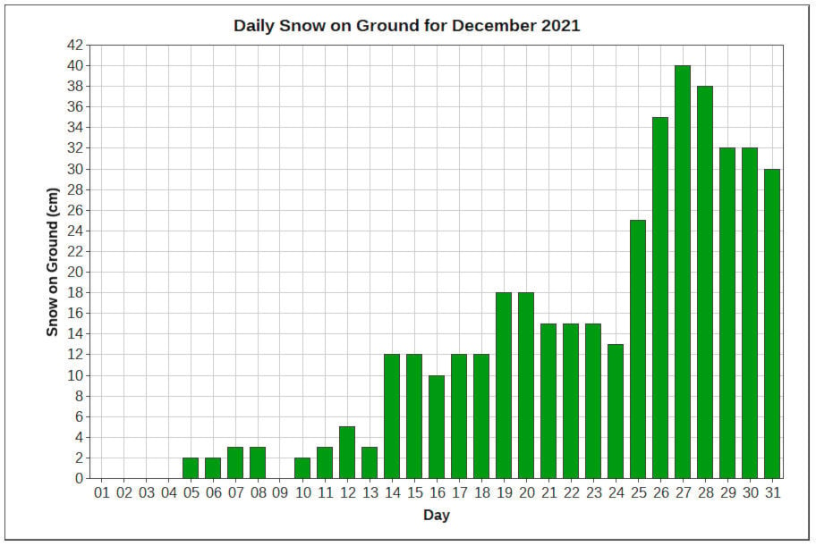
We can all recall but just a few weeks ago, when we woke to what one can only describe as a white Christmas. Over the course of several days we accumulated nearly 20cm of snow. It may have seemed like more in terms of the actual height of the snow, but data shows around 20cm over the course of the Christmas weekend.
On Dec. 27, 2021 Cranbrook had a total of 40cm of snow on the ground. That puts us just under the record for that date, with Dec. 27, 1996 sitting at 41cm.
If we are in for more precipitation over the next few weeks, it could prove to be a challenge come the spring melt. Snowpack levels are high in the East Kootenay region, having broken records in December and January.
According to the map of snow basin indices, the East Kootenay Basin is at 116 per cent of normal snow pack as of Dec. 1, 2021. This is an average of the three stations that are measured in the region.
For reference, in Dec. of 2020, the snow pack was at 90 per cent of normal.
According to this provincial data, the provincial average for all sites is 113 per cent as of Jan. 5.
An all-time record high snowpack for Jan. 1 was recorded at Floe Lake, which is in the East Kootenay region. During December, the snowpack at Floe Lake reached 173 per cent. It sits at 154 per cent as of Jan. 8.
The province says that the mountain snowpack accumulation season extends for another three to five months, but early normal to above normal snowpack conditions indicate an increased risk for snowmelt-related flooding during spring of 2022.
READ: Heavy rain, rising temperatures could mean floods on Lower Mainland, Vancouver Island
READ: 27 people rescued from floating ice chunk in Wisconsin bay
corey.bullock@cranbrooktownsman.com
Like us on Facebook and follow us on Twitter
Want to support local journalism during the pandemic? Make a donation here.