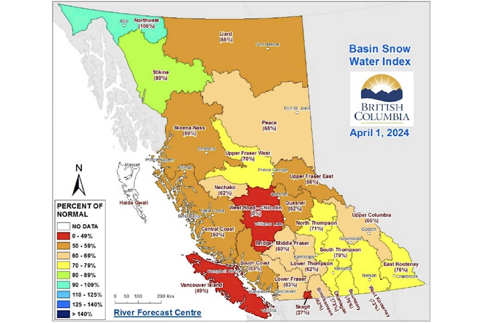
East Kootenay snowpack values have fallen slightly, as the provincial snowpack average is among the lowest in B.C.’s history, according to the latest update from the River Forecast Centre.
The East Kootenay average is 76 per cent of normal, dropping from the March value recorded at 81 per cent of normal.
Provincially, the average is 63 per cent of normal, as the April snowpack bulletin is considered the premier bulletin for assessing the year’s seasonal snowpack and comparing to historical years, according to Jonathan Boyd, a hydrologist with the River Forecast Centre.
This year’s lower snowpack will mitigate flood risks, but not fully eliminate them, said Boyd.
“What that low snowpack means is that the flood hazard from snowmelt this year is low and it’s especially noticeable through the larger systems, with the Fraser River, or the Thompson River, or the Skeena River,” Boyd said, during a media briefing on Wednesday, April 10. “A silver lining of this low snowpack is that areas that have been impacted consistently by flooding in recent years will have a lower risk this spring.
“It is still possible for adverse weather to cause flooding in the spring. Sudden and extreme rainfall or persistent periods of heavy rainfall can still cause flooding, especially small and medium sized rivers in the Interior. The spring is typically the wet season for the Interior.”
The winter months saw El Nino conditions, meaning warmer than normal temperatures and drier conditions. In low and mid-level elevations, earlier than usual snow melt and spring run off is already being observed, added Boyd.
In March, 28 snow stations in B.C. measured record lows for April 1. None were in the East Kootenay, however, three stations were in the Upper Columbia and one was in the West Kootenay.
In terms of forecasting drought conditions, there are many factors that are multi-faceted, said Boyd.
“While snowpack can play an important role in areas, other factors such as the rate of snowmelt, the spring and summer temperatures, short and long-term precipitation trends — they may all have equal or greater importance in the emergence of drought this summer,” Boyd said.